Hiking Around Chamonix: Trails, Balcony Paths and Lac Blanc
Can you hike around Chamonix without doing the Aiguille du Midi or the Mer de Glace?
Yes. Chamonix has an extensive network of marked mid-altitude trails, such as the Grand Balcon Sud and the Lac Blanc path, that are walked on foot rather than reached by cable car. They offer close-up views of the Mont Blanc massif, but they are separate outings from the Aiguille du Midi cable car or the Mer de Glace glacier visit.
Why Chamonix is a hiking destination, not just a cable car stop
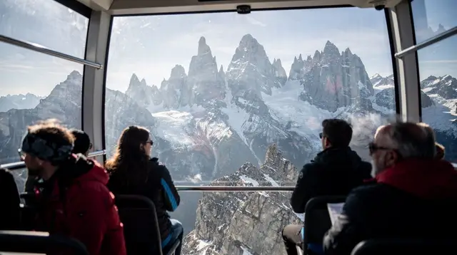
For a lot of visitors coming from Geneva, Chamonix means one thing: the ride up to the Aiguille du Midi for a view over the glaciers, or the trip out to the Mer de Glace to see the ice up close. Both are worthwhile, and both are covered elsewhere on this site. This page is about something different — the network of marked trails that circle the valley at mid-altitude, walked on foot, that let you spend a full day in the mountains around Mont Blanc without setting foot in a glacier cable car at all.
Chamonix sits directly beneath the Mont Blanc massif, whose summit, at 4,805m, is the highest point in the Alps. The town itself is at around 1,035m, and the trails described here mostly run between roughly 1,800m and 2,400m — high enough for real alpine views and real alpine weather, low enough to reach on a day trip without technical climbing gear. It’s about an hour to an hour and a quarter by road from Geneva, which makes it one of the most popular day trips from Geneva for hikers.
None of this is high-altitude mountaineering. But it isn’t a flat lakeside stroll either. Trails climb, terrain can be loose or exposed in places, and the weather at 2,000m can turn faster than it does in the valley. Treat these as genuine mountain hikes and plan accordingly.
The main trails, at a glance
| Trail | Typical distance | Elevation gain | Time (one way / loop) | Difficulty |
|---|---|---|---|---|
| Grand Balcon Sud (Planpraz to La Flégère section) | 8-11 km | 300-500m | 3-4 hours | Moderate |
| Lac Blanc from La Flégère | 8-10 km round trip | 700-900m | 4-6 hours round trip | Moderate to challenging |
| Plan de l’Aiguille loop trails | 3-6 km | 100-300m | 1.5-3 hours | Easy to moderate |
| Grand Balcon Nord (above the Mer de Glace side) | 10-14 km | 400-600m | 4-5 hours | Moderate to challenging |
These figures vary with the exact route and starting point, and they assume using the lifts to shortcut part of the ascent — walking from the valley floor adds substantially more distance and elevation gain to every one of them.
Grand Balcon Sud
The Grand Balcon Sud is the best-known balcony path in the Chamonix valley, tracing the mountainside above the town on its southern (sunnier) side, roughly facing the Mont Blanc massif across the valley. Most hikers start from the top of a lift — either the Planpraz cable car from Chamonix or the La Flégère cable car from Les Praz — and walk the connecting section between the two, which keeps the net elevation gain manageable while still delivering long, open views across the valley.
The trail is largely traversing rather than steeply climbing once you’re up at altitude, which makes it one of the more approachable balcony routes, though there are still sections with drops and uneven ground. On a clear day, this is one of the better vantage points for looking across at the glaciers and the summit ridge without doing the Aiguille du Midi excursion. It won’t put you as close to the ice as the Mer de Glace visit does, and it doesn’t reach the altitude of the Aiguille du Midi — this is a valley-side perspective, not a glacier-level one.
Lac Blanc
Lac Blanc — the “White Lake” — is the classic harder objective from La Flégère, and it’s the trail most often cited as the reward-for-effort hike of the Chamonix valley. The route climbs steadily from the top of the La Flégère lift through increasingly rocky terrain, with some sections using fixed cables or ladders on the steeper rock steps, before reaching the lake basin at around 2,350m.
The lake itself, when the ice has cleared (typically not before mid-to-late June, and sometimes later depending on the winter), reflects the Mont Blanc range on a still day — one of the most photographed spots in the valley. Getting there and back is a real day’s effort: figure four to six hours round trip depending on pace and how much time you spend at the top, plus a meaningful amount of elevation gain even starting from the lift. This is not a route for flip-flops or an impromptu detour; sturdy boots and a proper look at the weather forecast are worth the ten minutes it takes.
Plan de l’Aiguille — walking, not the cable car ride up
Plan de l’Aiguille, at around 2,317m, is a stop partway up the Aiguille du Midi cable car line — but it’s also reachable, and usable, as a hiking base in its own right, separate from continuing on to the summit station. Riding the cable car up to Plan de l’Aiguille and using it as a starting point for shorter loop trails is a genuinely different outing from the full Aiguille du Midi excursion to 3,842m: you get valley and glacier views from a lower, walkable plateau, rather than the high-altitude viewing platform near the ice itself.
From Plan de l’Aiguille, several shorter marked paths loop around the plateau and connect toward the Grand Balcon Sud, making it a flexible option for families or hikers with less time or a lower tolerance for long climbs. It’s worth being clear with yourself, and with anyone you’re travelling with, about which of the two experiences you’re booking — a hike from Plan de l’Aiguille is not a substitute for reaching the summit station, and vice versa.
Grand Balcon Nord and other longer routes
On the opposite side of the valley, trails collectively grouped under the Grand Balcon Nord run above the Mer de Glace side, offering views down onto the glacier’s retreating tongue and across to the Grandes Jorasses. These routes tend to be longer and less trafficked than the Grand Balcon Sud, with more sustained climbing and fewer easy bail-out points, so they suit hikers who already have a full mountain day or two under their belt in the region.
Other longer options exist throughout the valley — multi-day tours like the Tour du Mont Blanc pass through Chamonix — but those fall outside the scope of a single day trip from Geneva and require separate planning, accommodation booking, and often a guide.
Planning a day: fitness, altitude and weather
None of these trails require technical climbing skills, but all of them are real mountain terrain. A few points worth taking seriously:
- Fitness: even the “moderate” routes above involve several hours of walking with meaningful elevation change. If you’re not used to hiking regularly, choose a shorter loop (Plan de l’Aiguille) over a longer one (Lac Blanc or Grand Balcon Nord).
- Altitude: at 1,800-2,400m, altitude sickness is not a serious risk for most people, but the thinner air and stronger UV exposure are noticeable, especially on a first day at elevation.
- Weather: alpine weather changes quickly, and cloud can roll in over the massif within an hour, even on a morning that started clear. Check a mountain-specific forecast, not just the valley forecast, and be prepared to turn back.
- Footwear and layers: proper hiking boots with ankle support, and a packable waterproof/windproof layer even in summer — temperatures at 2,300m can be 10-15°C cooler than in the valley.
- Lift tickets: using the Planpraz, La Flégère or Aiguille du Midi lifts to reach a trailhead requires a ticket, and in July and August these can sell out or involve long queues without a timed booking.
None of this is meant to discourage a first-timer — these trails are walked by thousands of visitors of ordinary fitness every summer — but it’s worth going in with realistic expectations rather than treating it as a casual afternoon stroll.
What these hikes don’t include
It’s worth being explicit about the boundaries here, since the marketing around Chamonix can blur them. Hiking the Grand Balcon Sud, Lac Blanc or the Plan de l’Aiguille loops does not get you to the Aiguille du Midi summit station at 3,842m — that requires the cable car, a separate and much higher-altitude experience covered on its own page. It also doesn’t put you on the Mer de Glace glacier itself, which is reached by the Montenvers rack railway and involves a different kind of visit, including the ice cave dug fresh into the glacier each year. And on any of these mid-altitude trails, a clear, unobstructed view of the Mont Blanc summit is never guaranteed — the peak is frequently in cloud, particularly as the day warms up, regardless of how good conditions look down in the valley.
Combining hiking with other Chamonix experiences
A day built around one of these trails pairs naturally with a lower-key activity either before or after — many visitors hike in the morning while the light and weather are best, then wind down with something more relaxed later on. A guided sunset walk finishing with a mountain meal is a popular way to close out a long hiking day: the sunset hike with fondue in the alpine land combines a shorter guided walk with a traditional meal as the light changes over the massif.
If you’d rather have the structure of a full guided day from Geneva — transport, a knowledgeable guide, and a route matched to your fitness level — the private day trip to Chamonix and Mont Blanc is built around exactly that kind of flexibility, and can be a good option for a first visit to the valley.
For a different season entirely, once the trails are under snow, the same terrain becomes the starting point for winter outings — the snowshoeing excursion with local cheese and wine tasting covers some of the same lower slopes on foot, just with snowshoes instead of boots. And for those who want to see the massif from a completely different angle after a day on the ground, a tandem paragliding flight over the valley is a genuinely memorable way to end a Chamonix day — though it’s worth noting flights depend on wind and weather just as much as the hikes do.
Getting there from Geneva
Chamonix is roughly an hour to an hour and a quarter by road from Geneva, crossing from Switzerland into France en route — a reminder that, unlike a purely Swiss excursion, this trip does involve a genuine border crossing, even without passport checks at the frontier itself. Once in the valley, local buses and the télécabines at Planpraz, Plan de l’Aiguille (via the Aiguille du Midi line) and La Flégère connect the town to the various trailheads described above, so a car isn’t strictly necessary once you’ve arrived. For a broader look at what else the valley offers beyond hiking, see our Chamonix day trip guide and the Chamonix and Mont Blanc excursions guide.
If hiking is just one part of a longer visit, it’s worth planning the rest of your day around it — a one-day Mont Blanc itinerary from Geneva lays out how a hike, a cable car ride and a meal can fit into a single day trip without over-scheduling. And if you’re weighing Chamonix against other alpine bases in the region, our Chamonix versus Zermatt comparison covers how the two compare for a Geneva-based visitor.
Frequently asked questions about hiking near Chamonix
Do I need to book anything to hike near Chamonix?
Marked trails themselves are free and open access, but many popular routes use a lift for part of the ascent or descent, and those lifts can require timed tickets in high season. Check lift schedules and book ahead in July and August.
Is the Lac Blanc hike difficult?
It’s a genuine mountain hike with sustained climbing, loose rock in places, and several hours of walking depending on the route chosen. It suits hikers with a reasonable level of fitness and proper footwear, not a casual stroll.
Can beginners or families hike around Chamonix?
Yes, with the right route. Sections of the Grand Balcon Sud and the paths around Plan de l’Aiguille or Planpraz are gentler and can be shortened using the cable cars, making them workable for families and less experienced walkers.
Does hiking near Chamonix guarantee a view of Mont Blanc?
No. Mont Blanc is often veiled in cloud, especially by mid-morning, and alpine weather changes quickly. Trails offer some of the best vantage points in the region, but a clear summit view on any given day is never guaranteed.
How do the trails relate to the Aiguille du Midi and the Mer de Glace?
They’re different outings. The Aiguille du Midi is a cable car ride to a high-altitude platform near the glaciers, and the Mer de Glace is reached by a rack railway to a glacier viewpoint. The trails described here are walked on foot at mid-altitude and don’t lead to either site.
What should I pack for a day of hiking near Chamonix?
Sturdy hiking boots, layered clothing, a windproof/waterproof shell, sunscreen and sunglasses (UV is stronger at altitude), plenty of water, and a trail map or offline GPS app. Weather can shift fast even on marked mid-altitude paths.
How do I get from Geneva to the Chamonix trailheads?
Chamonix is roughly an hour to an hour and a quarter by road from Geneva. From the valley, local buses and the cable cars at Planpraz, Plan de l’Aiguille and La Flégère connect to the various trailheads.
Alpine and Lakeside Hiking
Verified deep-linked GetYourGuide tours. Book through these links and we earn a small commission at no cost to you.
GetYourGuide does not provide a product photo for this activity — the image shows the meeting point, photographed by us.