Hiking Mont Salève: Geneva's Nearest Mountain, Just Across the French Border
Can you hike Mont Salève as a half-day trip from Geneva?
Yes. The Téléphérique du Salève from Étrembières lifts you to about 1,100m in a few minutes, and marked trails to the Pitons du Salève (around 1,380m) take roughly 1.5 to 2.5 hours round trip. Because the cable car starts on French soil, bring a passport or ID card even for a short outing.
The mountain that watches over Geneva, from the wrong country
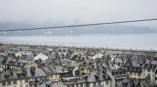
Look south from almost anywhere in Geneva and there’s a long green wall of rock rising above the rooftops — that’s Mont Salève. It reads as Geneva’s mountain, and locals treat it that way: an after-work walk, a Sunday picnic spot, a place to escape the lake-basin haze on a clear morning. What it isn’t, administratively, is Swiss. The entire massif sits in France, in the department of Haute-Savoie, and the cable car that gives most visitors their easiest access to it starts on French soil. That single fact — a mountain that feels like part of the city but legally isn’t — is the whole logic of this guide: how to get there, what the hike actually involves, what the view honestly shows, and why it’s a different kind of outing from a day trip to Chamonix or Mont Blanc.
None of this makes Mont Salève hard to visit. It’s arguably the easiest “real” hike within reach of central Geneva, doable in half a day without a car if you plan the transport. But a border is still a border, even a quiet one, and a few small facts — passport, weather, altitude — are worth knowing before you set out.
Bring ID, even for a short walk
Because the Téléphérique du Salève and every trail beyond it are on French ground, this is technically an international trip. Switzerland and France are both inside the Schengen Area, so there’s normally no passport control booth to stop at, no stamp, no formal crossing ceremony — but “no checks most of the time” is not the same as “no requirement.” A valid passport or national ID card is the legal minimum for crossing, and spot checks by French or Swiss authorities do happen, especially near the border zone. Bring the document. Leaving it in the hotel safe because “it’s basically still Geneva” is the single most common mistake visitors make about this hike, and it can turn an easy afternoon into a genuinely frustrating one if you’re checked without it.
This is also a good moment to be clear about what a Schengen border crossing does and doesn’t mean: Switzerland is inside Schengen but is not part of the European Union, so while passport checks are relaxed, customs rules on goods still exist and differ between the two countries. None of that affects a day hike with a water bottle and a sandwich, but it’s the same border logic that applies to bigger excursions like Chamonix or Annecy — Mont Salève is simply the smallest, closest version of the same crossing.
Getting to the cable car
The base station of the Téléphérique du Salève is in Étrembières, just across the border from Geneva — close enough that many visitors are surprised how quickly the city gives way to French countryside. It’s a short taxi or drive from central Geneva, and local bus connections link the Geneva side to the border area near the station, though there’s no direct tram or train running straight to the cable car itself, so it’s worth checking current routes and timetables before setting out rather than assuming a seamless public-transport link.
One practical note: the free Geneva Transport Card, covering Unireso buses, trams, and regional trains for visitors staying in registered Geneva accommodation, is a Swiss network product. It does not extend to the Salève cable car, which is a French operation with its own separate ticketing, priced in euros rather than francs. Budget for that ticket on top of anything you’re already using to move around Geneva.
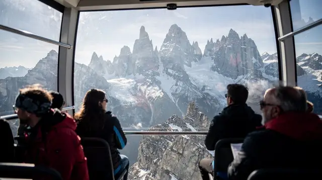
The cable car itself is quick — a few minutes of climbing that does the hard work of altitude gain for you, lifting riders from the valley floor to roughly 1,100 metres. That’s the real appeal of Mont Salève as a hiking destination: almost all the elevation is handled mechanically, leaving the walking for the part that’s actually rewarding — the ridge itself.
From the upper station to the Pitons du Salève
Stepping off the cable car at around 1,100m puts you on a network of marked trails, most of them wide, well-used, and only moderately technical. The main draw is the walk toward the Pitons du Salève, the highest points of the ridge, sitting around 1,380m — not a dramatic altitude gain from the upper station, but enough to change the view meaningfully as you climb.
Trail conditions are generally friendly: gravel and packed dirt paths, some rockier and more exposed stretches near the viewpoints themselves, and a scattering of picnic spots and paragliding launch points along the way (the Salève is a popular local paragliding site, and watching flights take off is part of the atmosphere). Sturdy walking shoes are worth having even though nothing here demands mountaineering gear — a casual sneaker will usually get you through, but a proper shoe makes the rockier sections more comfortable.
Round trip from the upper cable car station to the Pitons and back typically runs 1.5 to 2.5 hours at an unhurried pace, depending on which loop or viewpoint combination you choose and how long you linger. Several route options branch off from the upper station, so it’s easy to shorten or extend the walk depending on time and energy — this is genuinely a flexible half-day outing rather than a fixed-length trek.
| Segment | Approximate time |
|---|---|
| Cable car ride, Étrembières to upper station | 5-10 minutes |
| Upper station to Pitons du Salève | 45-75 minutes |
| Time at the summit viewpoints | 20-40 minutes |
| Return to upper station | 45-75 minutes |
| Total, cable car to cable car | About 2-3.5 hours |
Add travel time to and from Étrembières on both ends, and the whole outing — door to door from central Geneva — comfortably fits into a half day, leaving the rest of the day free for the Old Town or the lakefront.
What the view actually shows — and doesn’t
The reason people make the trip is the view, and on a good day it earns the reputation: Geneva laid out below, the blue sweep of Lake Geneva, the city’s Jet d’eau visible as a thin white plume from a distance, and — this is the part worth being honest about — the Mont Blanc massif on the horizon, weather permitting.
That last clause matters. The Mont Blanc view from Mont Salève is genuinely spectacular when conditions cooperate, but it is not a given. Geneva’s basin is prone to haze, and in winter especially to temperature inversions, where fog sits low over the city while the surrounding heights — including the Salève itself — poke up into clear sunshine above a “sea of clouds.” That inversion effect can actually make for a striking hike, but it also means the distant Mont Blanc panorama some visitors expect can be obscured by cloud sitting over the valley, or by ordinary haze on a humid day. Check a weather and visibility forecast before you go if the Mont Blanc view specifically is your reason for the trip, and treat a clear sighting as a bonus rather than a promise.
The reverse view is worth a comment too: yes, the Salève ridge is a constant, recognisable presence from many parts of Geneva, but that doesn’t mean the exact summit or the Pitons themselves are visible from every street or every window downtown — buildings, other high ground, and weather all shape what’s actually on view from the city side. It’s a backdrop, not a single fixed postcard shot available everywhere in town.
Mont Salève is not Chamonix — and that’s the point
It’s worth stating plainly, because the two get mentally lumped together as “mountains near Geneva”: Mont Salève and the Chamonix–Mont Blanc region are entirely different scales of outing, and treating them as interchangeable sets up the wrong expectations for both.
| Mont Salève | Chamonix / Mont Blanc | |
|---|---|---|
| Country | France | France |
| Distance from Geneva | Short drive/taxi to Étrembières | Roughly 1-1.5 hours by road |
| Summit altitude reached | About 1,380m (Pitons du Salève) | Aiguille du Midi cable car: 3,842m |
| Typical time needed | Half a day | Full day |
| Character | Local belvedere hike, city views | High-mountain glacier scenery |
| Booking needed | No advance ticket typically required | Timed cable car tickets, book ahead in high season |
Mont Salève is a proximity hike — a way to get a genuine sense of altitude, fresh air, and a wide panorama without leaving the Geneva area for long. Chamonix, by contrast, is a proper excursion: an hour-plus each way, and once there, the Aiguille du Midi cable car climbs to nearly 3,900 metres in stages, opening onto glacier terrain and high-alpine views that Mont Salève simply doesn’t have the elevation to offer. The Mer de Glace, reached separately by rack railway from Chamonix, adds another full high-mountain experience of its own — a retreating glacier you descend to on a staircase that gets longer every year as the ice thins.
Neither is “better” — they answer different questions. If the goal is a half-day breather with a view over the city and lake, Mont Salève delivers efficiently and without a long drive. If the goal is genuine high-mountain scenery — glaciers, extreme altitude, a cable car climbing into a different climate zone — that’s a Chamonix day, not a Salève afternoon, and it’s worth budgeting the extra travel time and a full day for it rather than trying to compress both into one outing.
For travelers weighing both, a guided option can simplify the bigger trip: a Chamonix and Mont Blanc day tour from Geneva bundles transport and the high-altitude cable car experience into a single organized day, which is a useful contrast to plan against once you’ve done the shorter Salève walk and know roughly how much time and effort each style of “mountain day” actually takes.
Other ways to spend a half-day of altitude near Geneva
Mont Salève isn’t the only nearby option if a lake-and-mountain outing is what you’re after. Further along the lake, the Lavaux vineyard terraces offer a gentler, lower-altitude walk through UNESCO-listed vine terraces above the water, while above Montreux the Rochers de Naye summit gives a higher-altitude alternative reached by cogwheel train rather than cable car — genuinely more of a mountain outing than Salève, with alpine flora and wider panoramas over the Swiss Riviera. A guided Rochers de Naye hike and picnic day trip from Montreux is a good comparison point if you want to see how a higher Swiss summit day differs from the shorter, more local Salève walk.
Closer to the city itself, and requiring no border crossing at all, a wander through Carouge, Geneva’s artisan quarter just south of the centre, makes an easy pairing with a Salève morning — arrive back from the mountain and spend the afternoon among its ochre facades, workshops, and cafés. Those who’d rather combine outdoor activity with something more playful on the Swiss side might look at a Carouge outdoor escape game paired with wine tastings, a low-effort way to fill the rest of a day that started with the cable car up to the Pitons.
Planning the rest of the day
Because a Mont Salève hike rarely fills a full day on its own, it pairs naturally with other half-day plans on either side of the lake. Coming back into Geneva with energy left, the lakefront promenades and the Jet d’eau make an easy, flat contrast to the morning’s climbing. Travelers building a longer itinerary around the region sometimes extend a lake-focused day with a visit toward Montreux and the Swiss Riviera — a day tour from Geneva to Montreux covers that stretch of lakeshore for those who’d rather not manage trains and boat connections themselves on a day that already started with a morning hike.
For a broader sense of how a Mont Salève morning fits into a wider Geneva stay, the one-day Geneva essentials itinerary and the dedicated Geneva transport guide are useful starting points — the transport guide in particular is worth reading before relying on the Geneva Transport Card, since, as noted above, it doesn’t extend across the border to the Salève cable car itself. If Mont Blanc rather than Salève turns out to be the real draw, the Mont Blanc excursions guide from Chamonix and the Aiguille du Midi excursions guide lay out that considerably bigger day in full, including the advance booking that high-season cable car tickets require. And for hikers who want to compare trail options more broadly around the region, the Chamonix hiking guide and the general hiking category page cover terrain well beyond what Salève’s modest ridge offers.
Practical notes before you go
A short checklist, since the details here are more about paperwork and weather than gear:
- ID: passport or national ID card, every time, even for a two-hour outing.
- Currency: the cable car and anything bought in Étrembières or on the French side is priced in euros, not Swiss francs.
- Transport card: the Geneva Transport Card and Unireso tickets don’t cover the Salève cable car — budget separately.
- Weather check: haze or inversion fog can hide the Mont Blanc view even on a day that looks clear from the city; check a visibility or webcam forecast if that’s your main reason for going.
- Footwear: not technical, but sturdy shoes make the rockier stretches near the Pitons more comfortable.
- Timing: the whole outing — cable car, walk to the Pitons and back, cable car down — fits comfortably into two to three and a half hours, making it genuinely feasible as one half of a fuller Geneva day.
None of this turns Mont Salève into a complicated trip. It remains the easiest “real” mountain outing within reach of Geneva — no early start, no long drive, no advance cable car reservation typically required. It just isn’t, technically, part of Switzerland, and a few minutes of preparation around that one fact is what keeps the outing simple instead of turning into an avoidable hiccup at the border.
Alpine and Lakeside Hiking
Verified deep-linked GetYourGuide tours. Book through these links and we earn a small commission at no cost to you.
GetYourGuide does not provide a product photo for this activity — the image shows the meeting point, photographed by us.